Most buyers reach us the week they find out their building needs evacuation maps. They have a floor plan in hand and no clear picture of what a compliant panel looks like. North Coast Signs starts that job with a phone call to the local fire marshal, before a single exit route is drawn. The rules for evacuation planning live in the fire code’s emergency planning chapter, and the local fire authority administers them. That call settles what your building falls under while the drawing is still open, and we set the panel count and the mounting points from the answer. Making that call first keeps you from reprinting panels later.
Which Buildings the Posting Rule Reaches
The state names the buildings it expects maps in. Buildings like hotels, motels, lodging houses, high-rise offices, and certain care facilities are required by state regulation to post floor-plan evacuation information. Under Title 19 those plans go at every stairway landing, every elevator landing, and immediately inside all public entrances, with the bottom edge no more than four feet above the floor. There is also a separate federal obligation that sits alongside the posted map, because most employers above a small headcount keep a written emergency action plan available to employees. The written plan does not satisfy the posting rule, and a building can owe both. Your fire marshal is the one who says which of these reach your building.
Orientation Changes With Every Wall
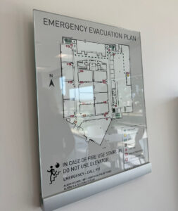
The accepted standard, widely followed as best practice, is that the plan is oriented to the direction the reader is facing. What sits on your left as you stand in the corridor appears on the left of the drawing. Your own position is marked on it. A panel hung on a west-facing wall therefore puts west at the top. Hang that same panel around the corner and it reads backward to the person standing in front of it. Walk one floor and count the spots that need one: six or more is normal, and each one is a different drawing with its own “You Are Here” mark. We build those layouts from your floor plan and mark the mounting point for every panel, including the ones by the stairwells and the elevator bank.
The Contents We Draw Onto Your Plan
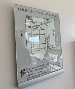
The content list comes from two places, the state rule and what a person can read while walking. Under the state rule the plan shows exit locations and fire alarm initiating stations, what the alarm sounds and looks like, the emergency number, and the prohibition on elevator use during an emergency. We add the primary and secondary exit routes in red. The fire extinguishers, the alarm pull stations, and the assembly area outside go on the same drawing. Because there is a United States standard for fire safety and emergency symbols, every panel in your building carries one consistent symbol and color system. A visitor who reads the map by the elevator recognizes the same marks at the stairwell.
Built to Hang in a Corridor for Years
We fabricated and hung a set of these maps for a Carlsbad business, and the build is what we would put on your floor. The panels run about 10 by 14 inches, and the printed sheet sits between two pieces of tempered glass. Tempered glass is roughly four times stronger than standard glass of the same thickness, which matters on a panel that hangs in a corridor and gets bumped and cleaned. The sheet inside is waterproof and tear resistant, so a routine wipe-down leaves the map intact. Brushed aluminum brackets hold the assembly to the wall, and the edges are finished smooth.
If you are putting evacuation maps up on a floor in Carlsbad, send North Coast Signs the floor plan for that level. We will call your fire marshal first. Then we bring back a layout that shows how many panels the floor needs, where each one hangs, and which way each drawing faces. We are fully insured and carry CA Contractor’s License #1017276, which matters when the work happens in an occupied building. Call us at (760) 536-5454 when the floor plan is in hand.